


le tilleul

Laurent53
User
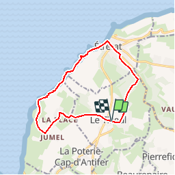

Length
11.9 km

Max alt
111 m

Uphill gradient
280 m
Km-Effort
15.6 km

Min alt
2 m

Downhill gradient
279 m
Boucle
Yes
Creation date :
2019-08-05 09:49:48.934
Updated on :
2019-08-07 16:31:07.099
--
Difficulty : Easy

FREE GPS app for hiking
 SityTrail
IGN / Geographical institutes
SityTrail Plus
The world is yours!
About
Trail On foot of 11.9 km to be discovered at Normandy, Seine-Maritime, Le Tilleul. This trail is proposed by Laurent53.
Photos

Positioning
Country:
France
Region :
Normandy
Department/Province :
Seine-Maritime
Municipality :
Le Tilleul
Location:
Unknown
Start:(Dec)
Start:(UTM)
298386 ; 5507121 (31U) N.
Comments
superbe randonnée